 Online Mooring lets you visualize and validate the location of your resources through the use of online charting technology. Our charts are interactive, so the charts update as you move through your harbor, so that you can see what is around you at any time.
What can you see on the charts?
- Berth locations (moorings, slips, floats, drystalls, etc.). For each berth location, we can show where the berth is supposed to be, as well as where it was most recently found.
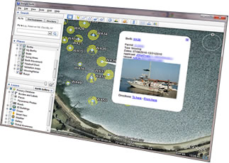 Berths can be color coded based on information in the database, such as the current status of the berth (in use, or not in use). Berths can be labeled using any field from the database (including berth numbers, permit numbers, applicant names, vessel names or registration numbers, etc.). Clicking on a berth shows you summary information about the berth and and any permits associated with the berth, and allows you to click for more detailed information.
- Swing areas. These are the areas around each berth where the vessel may be located. The areas depend on many factors, including the physical characteristics of the berths, the physical characteristics of the vessel, and the physical characteristics of the waters.
- Berth Movement. This shows any movement between the expected and actual locations of each berth, including information about distance and bearing that the berth needs to move to get it back to its expected location.
- Selected Berths. Shows the berths that appeared in your most recent web site search results.
- My Berths. Shows the berths that a boater is allowed to use.
- Validation Areas. Shows any areas you have defined where berths are allowed or restricted.
- NOAA Charts. Scanned images of NOAA charts.
- Aerial Photography. Aerial photos of your area, updated on a continual basis.
- Custom Layers. You can define additional points, lines, and areas that you'd like to show.
How do we validate berth locations?
We let you define areas where berths are allowed, or where they are prohibited. For example, you can define the locations of navigation channels, or sensitive environmental areas, or land areas, and we'll prevent anyone from entering coordinates that fall inside any of those areas. Alternatively, you can define one or more approved areas for berths, and we'll ensure that any coordinates entered fall within an approved area.
What software do you need to view the charts?
Just a web browser. The standard interface for the charts is Google Maps (using your web browser) or Google Earth (a free download).
You don't need to purchase of Geographic Information System (GIS) software. Online Mooring supports converting data to and from standard ESRI data formats.